My first goal was the climb to Fairbrook Naze. I decided to take the direct route to the Naze itself rather than following the path by the Stream. This involved walking through heather moorland to get to the foot of the climb.

Fairbrook Naze itself is on the eastern tip of Kinder North Edge. It is shaped like a giant V with a ridge running up the middle. My route followed this ridge which was rather steep with rocky outcrops and boulders.


As the climb levelled out towards the top I paused to take in the view. A Cloud Inversion had been forming further down the Woodlands Valley and it was gradually becoming an impressive sight.

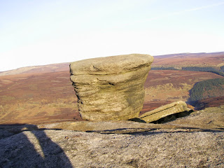
The top of Fairbrook Naze itself is a facinating area of Kinder Scout. There are rocky outscrops, a gritstone rock pedestal shaped by the weather, rocky ledges and the most unusual rock formations.


Fairbrook Naze is also a brilliant view point looking over towards the moorland of Bleaklow and down the Woodlands Valley towards Ladybower Reservoir where, today, the inversion had formed.


The next stage of my walk was across the Peat Channels of Kinder Plateau to join up with the river Kinder at at Kinder Gates. To begin with I followed the channel cut by the River Fairbrook before turing off to cut across the groughs. The sun was shinning brightly, and everywhere was very silent. Much of the peat was frozen hard. I had been walking for 20 minutes across this rough terrain when the ground levelled out and became a flat layer of peat and glassy ice. When I stopped walking to take in the sight, I could hear the ground all around me cracking as frozen earth was thawing under the winter sun.
As I pressed on the ground turned to rough peak channels, and I eventually joined with the River Kinder just before the huge gritstone rocks of Kinder Gates, between which the frozen river course passed.

From here I walked alongside the sandy river bed,crossing the ice here and there to find the best path. Eventually I arrived at Kinder Downfall and the western edge of the Kinder Plateau.
Kinder Downfall is where the River Kinder reaches the edge of the plateau and pours over the rocky cliffs at the apex of an inverted v. When I visited this sport two days earlier there was a strong easterly wind and freezing temperatures. Today, however, there was no wind, and the sun shone warm and bright. I sat on a rock facing south east looking across the High Peak area of the district.

when I first got there mist had already started to settle lower down in the valleys. Gradually more mist formed and the hill tops started to look like islands across a sea of white. The white stretched over the whole of the Cheshire Plane towards Wales on the far horizon. I have been to this area many times over the years but I had never seen the view looking like this:


After I finished my lunch I set off north west along the Plateau Edge. I looked back frequently to see the the white blanket of cloud covering the landscape. If anything the low cloud seemed to be getting thicker and more atmospheric. It was a shame when I reached the north western tip of the plateau and turned east along the Kinder North Edge, leaving this scene behind.
The north edge of Kinder is really impressive itself, of course. I was there two days ago traveling in the opossite direction. As I mentioned before the weather conditions were differnet that day. Today, looking over heather moorland to the north was very clear and visibility was good. I gradually made my way across the rocks, bolders and peat hags back towards Fairbrook Naze where my journey over Kinder Scout began earlier in the day.
Once there I stopped to look east down the Woodland Valley. The cloud Inversion from the morning had become thicker and had now reached the the River Fair Brook below Fairbrook Naze where I stood. After taking in this amazing scene, I retraced my steps down the ridge from the morning, and headed down into the freezing mist and back to the Woodlands Valley where I started my walk.


No comments:
Post a Comment